Chapter 1- IX- INDIA SIZE AND LOCATION
India is one of the ancient civilizations in the world. It has moved forward, displaying remarkable progress in the field of agriculture, industry, technology and overall economic development. India has also contributed significantly to the making of world history.In this chapter you will get to know about India’s exact location, extent and time zone, It's contact with the world through all the routes for Trade and Commerce, it's neighbors, states and union territories.
INDIA: LOCATION
To know about India's location a few general concepts we should know like longitudes and latitudes which will give us a exact idea of India's location in the world.
Latitude: It is an angular distance, North or South from the equator, of a point on the earth's surface. The equator is 0o and points can therefore be measured in degrees south and Northof this line.
Longitude: It is an angular distance of a point measured on the earth's surface to the East or West of a central reference point. The reference point in this case is the plane created by a meridian going through Greenwich in England. It is 0o meridian.
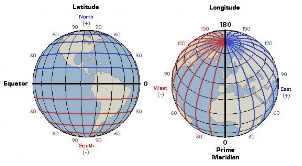

- India lies in the Northern and Eastern hemisphere.
- The mainland stretches from Latitude 8o4' North to 37o6' North and from Longitude 68o7' East to 97o25' East.
- The latitudinal & longitudinal extent of the country is almost same in degrees i.e. about 30o.
- The southernmost point in the Indian Territory, (in Great Nicobar Islands) is the Indira Point (6o45' North), while Kanya-kumari, is the southernmost point of Indian mainland.
- Tropic of Cancer crosses the country at 23o30' North dividing the country into almost two equal parts.
Size of India:
- India is the seventh largest country in the world covering an area of 3.28 million square kilometers.
- India covers 2.4 % of the total geographical area of the world.
- The country is of a vast size and measures about 3,214 kilometers from North to South and about 2,933 kilometers from West to East.
- Coastline: 7,516.6 km encompassing the mainland, Lakshadweep Islands, and the Andaman & Nicobar Islands.

- The 82o30' East longitude is taken as Standard Time Meridian of India, as it passes through the middle of India (Mirzapur in Uttar Pradesh).
- Indian Standard Time: GMT + 05:30.
- Now a question comes in mind
Why 82o30' East longitude (Mirzapur in Uttar Pradesh) is taken as the Standard Time Meridian of India?
Ans:
- The longitudinal extent of India is 30o.
- The sun rises in the east and sets in the west.
- It takes 4 minutes for the sun to move across 1 longitude.
- Earth takes 1day=24 hours to complete 360 degrees. So, 24/360 Χ 60 = 4mins
- Thus, the eastern most point of India would be 2 hours ahead of the western most point (30 x 4 = 120 minutes), in accordance with the local time.
- This difference in time might create confusion in air and rail timings and so many other things across the two states. To avoid this confusion a longitude passing through the midpoint of 68o7' East (western most longitude) and 97o25' East (eastern most longitude) is taken as the standard prime meridian of India (i.e. 82o30').
- The calculation is:
- 68o7'E + 97o25' E ÷ 2 = 166'32o
- 166'32o ÷ 2 = 82o30' approx
- The time at the standard meridian 82o30' which passes through Mirzapur in UP is taken as the standard time of India, followed all over the country.
India and the World:
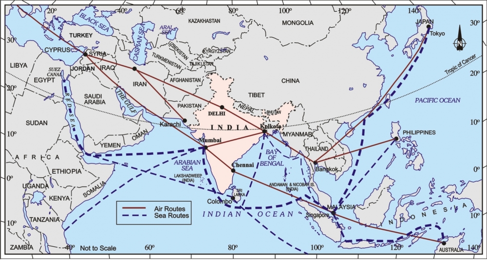
- India is centrally located between the East and the West Asia.
- India is located at the centre of the trans-Indian Ocean routes which connect the European countries in the west and the countries of East Asia.
- India has established close contact with West Asia, Africa and Europe from the western coast. Also, contact with Southeast and East Asia from the eastern coast.
- India has longest coastline on the Indian Ocean.
- India's contact with the world through land routes is much older than the sea routes.
- Through these routes people around the world have come to know about India's culture and traditions.
- The spices, muslin and other merchandise were taken from India to different countries.
- On the other hand, the influence of Greek sculpture, and the architectural styles of domes and minarets from West Asia can be seen in different parts of India.
India's Neighbours:
- India has 28 states and 8 union territories.
- In the northwest, India shares its boundaries with Pakistan and Afghanistan.
- In the north, India shares its boundaries with China, Nepal and Bhutan.
- In the east, India shares its boundaries with Bangladesh and Myanmar.
- In the south, India shares its boundaries with Maldives and Sri Lanka. Sri Lanka is separated from India by a narrow channel of sea formed by Palk Strait.

To know in detail about all states: https://www.mapsofindia.com/states/
SOME CONCEPTS RELATED TO THE CHAPTER
Strait: A narrow passage of water connecting two seas or two other large areas of water.
The palk strait is the smaller water body which connects two bigger water bodies that is bay of bengal and Indian Ocean.
for another example take "the Straits of Gibraltar". Find out where is it located?

Sub Continent: The Indian subcontinent, or simply the subcontinent, is a physiographical region in southern Asia, situated on the Indian Plate and projecting southwards into the Indian Ocean from the Himalayas.
The Indian subcontinent is a term mainly used for the geographic region surrounded by the Indian Ocean: Bangladesh, Bhutan, India, Maldives, Nepal, Pakistan and Sri Lanka.

Check the link for full chapter video along with Question answer


It is very informative & useful for us because it is given in points and proper explanation of question is also given.
ReplyDeletethankyou very much.
Delete